About a year ago we did some workshops with the BBC, to look at new ways in which history could be explored and explained using digital media. We came up with 30 or so ideas which got narrowed down to 5 ‘microbriefs’ for possible future prototyping.
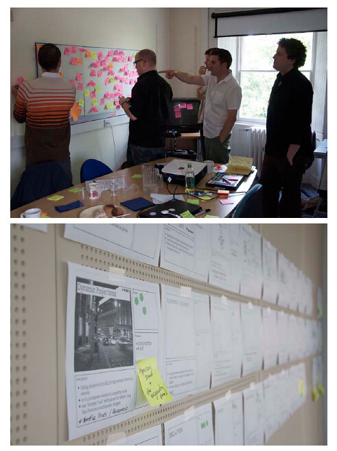
One of our favourites from the off was an idea we called “Dimensions”.
From our original concept document:
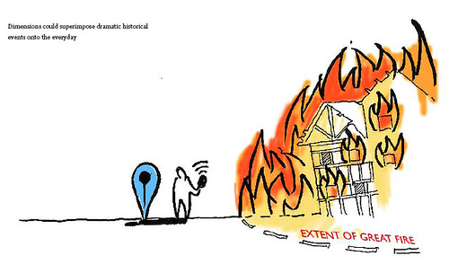
“We want to bring home the human scale of events and places in history. The Apollo 11 Moon walk explored an area smaller than Trafalgar Square; the distance between your WW1 trench and the enemy could only be as much as from your front door to the street corner.
Dimensions is a feature on websites that juxtaposes the size of historical events with your home and neighbourhood. You’re hearing about the span of the base of the Great Pyramids, or the distance of the book depository from JFK, or the extent of the Great Fire of London… Dimensions overlays this map on a satellite view of where you live.”
Earlier this year we began to design and build a public prototype of the BBC Dimensions concept which we’re putting live today.
It lives at http://howbigreally.com and it’ll be available as a trial for the next few months.
Let me give you a little tour.
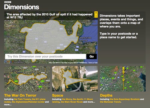
The home page is a collection of what we’ve been calling ‘packages’ – themed collections of ‘Dimensions’. For instance here: ‘The War On Terror, ‘Space’ and ‘Depths’
What’s a Dimension then? Well, basically what it says right there on the homepage: “Dimensions takes important places, events and things, and overlays them onto a map of where you are.”
You can have a play right there and then by entering your postcode or a place name. It understands most things that google maps understands. We’ve built the prototype using google maps, but there’s no reason why it couldn’t work on top of another mapping system eventually.
As we were building the prototype, the BP Deepwater Horizon oil-spill disaster occurred, and you might have seen the excellent visualisation at http://www.ifitwasmyhome.com/ by Andy Lintner.
When we saw that and how well it was received – we knew we were on the right track! Dimensions is a platform to explore a lot more in that vein.
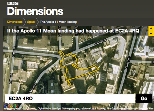
Wandering into the ‘Space’ package reveals a few different types of dimension – sizes, plans, routes.
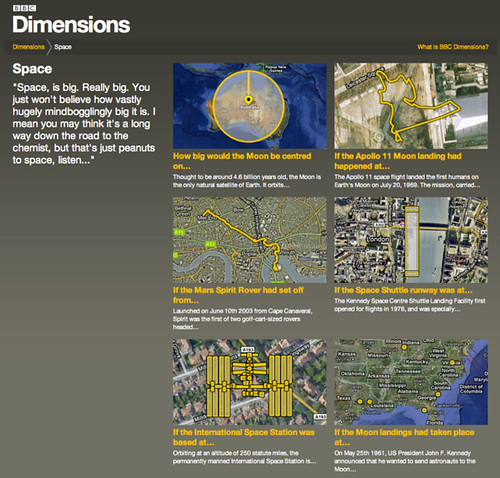
The routes, such as that taken by the Apollo 11 moonwalkers mentioned in the original concept really can be revealing when juxtaposed on your postcode, or an area you know well…
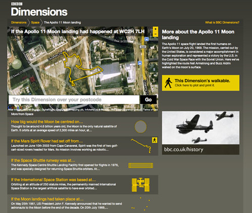
For instance if I type in our studio’s postcode…
I can see that Buzz and Neil would have barely left the building’s carpark…
Some Dimensions let you go a step further, literally – by allowing you to plot a route around your neighbourhood, or perhaps your commute, or perhaps a nearby bit of countryside – so that you can viscerally experience the distances involved.

You point and click on the map to make your walk like so – a little gauge runs along the bottom so you can see how far you have left to plot…

…and when you’re happy with your route you can print out a map to take on your dimensional ramble.
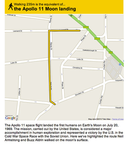
The distance just about takes us from the front-door of our studio to a refreshing pint in one of our locals, The Book Club. Just the thing after a moonwalk.
And that’s Dimensions!
One of the things I love about it is things like that – where something huge and momentous is made grokkable in the familiar. I also love that that’s all it really does.
It’s a bit like a digital toy – that just does one thing, very clearly (we hope) and delights in doing so.
It’s imagined that if the prototype is successful, it will be integrated into the main BBC site for embedding into history and news storytelling online.
The prototype system that we’ve made allows designers and producers at the BBC to create as many Dimensions as they want to using standard SVG creation tools. It’s also possible that this system could be opened up for local history enthusiasts to create their own dimensions to contribute.
The BBC worked with KeltieCochrane to create the initial content that’s in this prototype, and it was fantastic to see the system we built fill up with their work. My favourite’s The Colossus of Rhodes. Brilliant.
We’ll write some more here about both possible futures and the behind-the-scenes of Dimensions later. In the mean-time, many thanks to Matt Brown, Tom Armitage, Matt Webb, Phil Gyford and Paul Mison who worked on this with me, and Max Gadney for giving us a lovely brief.
Alan Kay once said that “A change of perspective is worth +80 IQ points”– that’s the goal of BBC Dimensions. So long as it delivers tiny bursts of that along with the little grins of ah-ha it seems to generate, we’ll be very happy.
You can find the BBC Dimensions prototype at http://howbigreally.com
22 Comments and Trackbacks
1. Cait said on 17 August 2010...
Oh. Wow.
This is stunning. My head just exploded. I cannot *wait* to overlay the Apollo moon mission walk on to Streatham common and do it with the kids.
So excited I immediately want to play. Jumping up and down on the spot with glee at how awesome it is!
Big hugs and kisses to all.
xxx
2. sbd said on 17 August 2010...
This is a beautiful idea. It really does demo the human scale of events. Very clever.
3. Tom Carden said on 17 August 2010...
Well done for dealing with the distortions inherent in the choice of map projection!
The maths is a little tricky (moving from absolute coordinates to “turtle” coordinates with angle and distance, right?) but I’ve seen a few examples of people trying to compare images on Google Maps from one place to another without taking the projection into account. And the Mercator projection is a beast: http://www.perrygeo.net/wordpress/?p=4
I didn’t realise ‘If It Were My Home’ got it right too. It’s really useful! Check out Greenland or Canada for examples http://www.ifitweremyhome.com/compare/US/GL http://www.ifitweremyhome.com/compare/US/CA
Anyway, carto-wonkery aside I’d love to read about the methodology, and the authoring/editorial process too, if you have time to write it up? Great work!
4. Michael B. Johnson said on 17 August 2010...
This is great! I’ve been thinking lately how much I wish that the MapKit.framework on iOS would let you swap in your own maps (wander around Dune or MiddleEarth, anyone?) mapped on to the real world, which would let you geo-tag “photos” in another world. Imagine the awesomeness that would be the ancillary materials of a film if you could map it on to a place in the real world. Pair it up with an augmented reality game, and I think it could be an extraordinarily immersive experience.
Neat stuff, guys. Wish you lived closer…
5. Adam Nieman said on 18 August 2010...
Really nice work, with lots of further potential too. We at Carbon Visuals have had a tool for visualising carbon footprints this way for a while. See: http://carbonquilt.org. We call this approach to data visualisation ‘reality augmented data’. It is augmented reality turned on its head because you are not adding a layer of data to the real world but rather co-opting the world to provide a context for data. See: http://carbonquilt.posterous.com/rad-augmented-reality-turned-on-its-head. The approach treats viewers’ embodied experience of the world – their sense of what the world ‘feels like’ – as a resource for making otherwise alien or abstract quantities meaningful.
6. pab said on 18 August 2010...
Doesn’t the Space Shuttle runway look a little small to you?
Is it a deliberate mistake? Go on, if you claim it is no-one will ever notice you were out by a factor of ten or so
Trackback: links for 2010-08-17 | A Web editor's tale 17 August 2010
[…] Introducing BBC Dimensions – BERG "About a year ago we did some workshops with the BBC, to look at new ways in which history could be explored and explained using digital media. We came up with 30 or so ideas which got narrowed down to 5 ‘microbriefs’ for possible future prototyping. " (tags: bbc dimensions bbcdimensions berg mapping maps mashup local history geo) […]
Trackback: Digital Stuffing » Blog Archive » links for 2010-08-17 18 August 2010
[…] Introducing BBC Dimensions – Blog – BERG We want to bring home the human scale of events and places in history. The Apollo 11 Moon walk explored an area smaller than Trafalgar Square; the distance between your WW1 trench and the enemy could only be as much as from your front door to the street corner. Dimensions is a feature on websites that juxtaposes the size of historical events with your home and neighbourhood. You’re hearing about the span of the base of the Great Pyramids, or the distance of the book depository from JFK, or the extent of the Great Fire of London… Dimensions overlays this map on a satellite view of where you live.” (tags: bbc mapping mashup) […]
Trackback: How Big Really? | Inventing Interactive 18 August 2010
[…] you can see how the moon walks compare to your backyard! Created by BERG, there’s a great description of the project’s […]
Trackback: How Big Really? | Inventing Interactive 18 August 2010
[…] you can see how the moon walks compare to your backyard! Created by BERG, there’s a great description of the project’s […]
Trackback: Korta klipp – 19 August 2010 19 August 2010
[…] Introducing BBC Dimensions – Blog – BERG […]
Trackback: links for 2010-08-19 19 August 2010
[…] Introducing BBC Dimensions – Blog – BERG Kevin: A look at howbigreally.com and the thinking behind it from BERG and the BBC. "We want to bring home the human scale of events and places in history. the Apollo 11 Moon walk explored an area smaller than Trafalgar Square; the distance between your WW1 trench and the enemy could only be as much s from your front door to the street corner." The website is currently (as of August 2010) a public prototype. It was crashing a few hours after its launch, but it's worth a look. (tags: history storytelling visualisation BBC BERG 2010) […]
Trackback: Rattle » Week #1278 22 August 2010
[…] Berg’s Dimensions, which is fabulous in its simplicity of thought but quite profound in its use of grok and the interpretive effects it enables. […]
Trackback: Школа мультимедийной журналистики » Новый интерактивный вебсайт ВВС 23 August 2010
[…] Для посещения вебсайта BBC Dimensions нажмите здесь. О создании проекта можно прочитать здесь. […]
Trackback: Links for 2010-08-17 [del.icio.us] | The Online Blog 23 August 2010
[…] Introducing BBC Dimensions – Blog – BERG http://howbigreally.com/ — "like a digital toy – that just does one thing, very clearly (we hope) and delights in doing so. … Alan Kay once said that “A change of perspective is worth +80 IQ points”- that’s the goal of BBC Dimensions. So long as it delivers tiny bursts of that along with the little grins of ah-ha it seems to generate, we’ll be very happy." […]
Trackback: links for 2010-08-24 « Sameer Padania 24 August 2010
[…] Introducing BBC Dimensions – Blog – BERG Oh God. More brilliance from BERG: http://bit.ly/dznDMe Simple, brilliant, fun. #humanrights applications galore. (tags: humanrights via:twitter) […]
Trackback: BBC Dimensions Physically Visualizes History - PSFK 24 August 2010
[…] Berg […]
Trackback: adaptive path » blog » Adaptive Path » Signposts for the Week Ending August 27, 2010 28 August 2010
[…] BERG London introduces BBCs Dimensions http://berglondon.com/blog/2010/08/17/introducing-bbc-dimensions/ […]
Trackback: knit one street purl one city » polaroid sx-70 by ray and charles eames 28 August 2010
[…] The two cameras I feel most comfortable with are the rolleiflex 3.5F and hasselblad 500c/m. That’s why all my images are square, like the SX-70. This camera is grokkable, as described by the phenomenal berg. […]
Trackback: Overlay of Chernobyl cloud if it had happened in Chicago, « Christopher A. Haase 9 September 2010
[…] Built by BERG, the BBC Dimensions site allows you to overlay the geographies of historical events and significant places onto more familiar locales. Here's the Apollo 11 Moon walk positioned over the Statue of Liberty, the size of the radiation cloud if Chernobyl had happened in Chicago, and the Marianas Trench stretching from Manhattan's West Village to Sunset Park in Brooklyn. […]
Trackback: irvinebrown » BBC Dimensions 15 January 2011
[…] As Matt Jones writes, BERG were tasked with “looking at new ways in which history could be explored and explained using digital media.” This started as a series of workshops which ended up with the prototype we can see today. […]
Trackback: The Conference, dag 1 « Selfmade 25 August 2011
[…] flera exempel på innovativa, konstnärliga designprojekt (som Feltrons årliga rapporter eller BBC:s Dimensions). Skillnaden mellan konst och design, menar Antonelli, är att en designer alltid kan stå till […]