I’m going to tell you a little bit about the influences on Here & There, a project about representation of urban places, from when it began. It was warmly received when I first presented some corners of it back at Design Engaged in 2004, before Schulze & Webb existed. Here & There is a projection drawing from maps, comics, television, and games.
This particular version is a horizonless projection in Manhattan. The project page is here, where large prints of the uptown and downtown views can be seen and are available to buy.
I’ve been observing the look and mechanisms in maps since I began working in graphic design. For individuals, and all kinds of companies, cities are an increasing pre-occupation. Geography is the new frontier. Wherever I look in the tech industry I see material from architects and references and metaphors from the urban realm. Here & There draws from that, and also exploits and expands upon the higher levels of visual literacy born of television, games, comics and print.
The satellite is the ultimate symbol of omniscience. It’s how we wage wars, and why wars are won. That’s why Google Earth is so compelling. This is what the map taps into.
The projection works by presenting an image of the place in which the observer is standing. As the city recedes into the (geographic) distance it shifts from a natural, third person representation of the viewer’s immediate surroundings into a near plan view. The city appears folded up, as though a large crease runs through it. But it isn’t a halo or hoop though, and the city doesn’t loop over one’s head. The distance is potentially infinite, and it’s more like a giant ripple showing both the viewers surroundings and also the city in the distance.

Origins and sources
Some of my favourite maps are drawn by a British writer, walker and accountant named Alfred Wainwright. Phil Baines provides background:
“Wainwright was an accountant born in Lancashire who fell in love with the English Lake District and moved there to live and work. All his free time was spent walking the fells, and he began his series of seven ‘pictorial guides to the Lakeland Fells’ in 1952 as a way of repaying his gratitude to them. The work took 13 years.” (Type & Typography)
Wainwright’s walking maps are drawn to suit their context of use, the books are intended to be used while walking. As the reader begins their walk, the map represents their location in overview plan. As the walk extends through the map, the perspective slowly shifts naturally with the unfolding landscape, until the destination is represented in a pictorial perspective view, as one would see it from their standpoint.
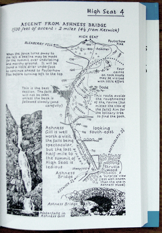
This is a reversal of the Here & There projection. In Wainwright’s projection we stand in plan, and look into perspective. Wainwright’s view succeeds in open ground where one can see the distance… but in a city you can only see the surrounding buildings. Wainwright and Here & There both present what’s around you with the most useful perspective, and lift your gaze above and beyond to see the rest.
David Hockney presents a fantastic dissection of perspective in the film A Day on the Grand Canal with the Emperor of China or Surface Is Illusion But So Is Depth. He describes a very old painting from China which depicts a journey along the grand canal. I really like how he describes the scene as ‘making sense.’
He justifies a deviation from Western perspective, that to represent things as they strike your eye is not even functionally as good as some other interpretative distortions. In this painting in which there’s a grossly distorted perspective, in which there aren’t even any rules, it still makes sense because it changes how you put yourself in the painting, and that changes where you put yourself outside it.
Augmented reality
There is a element in the map, in the uptown view, of a bus. Its destinations in both directions are shown. (I love NY bus routes, the cross town super power!) This is to explore how augmenting the map with local information might work.

One of my intentions with the project is to make an exploration into way-finding devices. One of my favourite examples of augmented reality is from these American Road maps from 1905. The map is stored in a book, and good for only one route. In fact, it isn’t a map as we’d typically understand one.
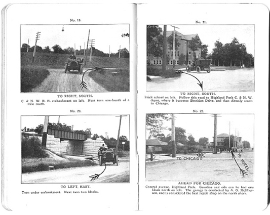
Michaels, H. Sargent. Photographic Runs: Series C, Chicago to Lake Geneva to Delavan, Delavan to Beloit. Chicago: H. Sargent Michaels, 1905. Used with permission from Prof. Robert French, Osher Map library, University of Southern Maine, Owls Head Transportation Museum.
The book dates from before the national road sign infrastructure was introduced to American highways or inter-city roads. Each page is a photo of a junction, with every junction between the two cities included, and an arrow is drawn over the photo to say which direction to take. As the driver progresses along their route, they turn pages, each junction they arrive at corresponding to the one in the current photo. (Many thanks to Steve Krug for the sharing his discovery of these great pieces.)
First person to God games
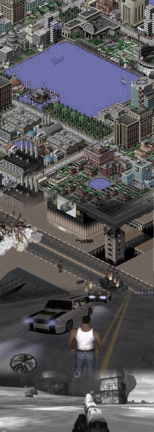
I don’t like the way maps (in-game maps) work in most video games. They seem to break my flow of play, and locating one’s actor in the game isn’t satisfying. I’d love to see a first person or third person shooter where the landscape bent up to reveal a limited arc of the landscape in plan over distance. As a video game, the Here & There projection slides from Halo, through GTA into Syndicate, to end in SimCity.
Although I never played it, I’ve heard a lot about Luigi’s Mansion for the Nintendo GameCube. Luigi wonders around a haunted mansion and hoovers up ghosts with a vacuum cleaner. I heard about a mechanic in the game which involved a virtual Gameboy Advance in the game. Luigi could take it out and use it to inspect the world. The game played out in the third person with a view of Luigi in place, but I think when you look in the Advance, it gave a first person view from Luigi’s position. Well, if it didn’t, it should have done.
I know that in some special games the Gameboy Advance could be plugged into the GameCube, to be used as a special controller. It would be amazing to use the second screen in a controller for that first person perspective. Imagine if you could guide your actor around in third person and glance down at the screen in your hands for close inspection or telescopic sniping.
Powers and cities
Recently Matt Jones and Rod Mclaren discussed Jason Bourne and James Bond and how they use cities. Jones characterises Bourne in contrast to Bond:
“… in addition, Bourne wraps cities, autobahns, ferries and train terminuses around him as the ultimate body-armour”
For Bourne, the city is his power, Jones continues:
“A battered watch and an accurate U-Bahn time-table are all he needs for a perfectly-timed, death-defying evasion of the authorities.”
I like to talk about the projection as a superpower, the power to be both in the city and above it.
Last year Warren Ellis wrote an Iron Man arc called Extremis. As ever, fine stuff. And with great pictures from Adi Granov too.
Ellis, unsatisfied with controlling the Iron Man suit by normal means (sensors, or weeny joysticks in the gloves or something) as an exoskeleton (picture Ripley in the clumsy Powerloader), Stark must ingest the Extremis serum in order to match his enemy, Mallen, and prevent him from his destructive path into Washington. The serum welds Stark to his tech. It leaves him ‘containing’ the membrane-like ‘undersheath’ he uses to control the Iron Man suit. It is stored inside his bones.
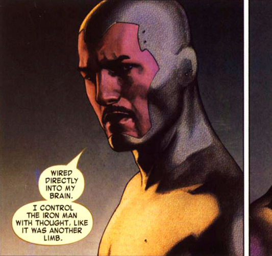
The final sequence of panels in the penultimate book has Stark wearing the Iron Man suit, setting off to confront his enemy, his recent transformation has left him with new powers…
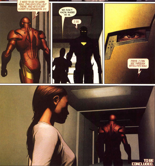
“I can see through satellites now.”
What a thought! Within one field of view, to be both in the world and to see yourself in it. The power of looking through, and occupying, your own field of vision. Awesome.
What if the projection appeared inside location-aware binoculars? Hold them up, and live satellite images are superimposed in ‘the bend’ onto the natural view of the city as it lifts up into plan! You’d see the traffic and people that just pulled out of view into a side street from above mapped onto your natural view.
Timo Arnall posted a video showing a Google Streetview pan controlled with the digital compass inside the device:
It begins to reveal how Here & There might feel if it were moving beneath your feet.
Thanks
I would like to thank both James King (art direction) and Campbell Orme (technical direction) for their tireless efforts in bringing this work to life. Email them and make them work on your stuff. They are talented, humane and brilliant designer/thinkers.
Art prints of Here & There have been produced in a limited run and can be purchased here. Please buy one and stick it on a wall.