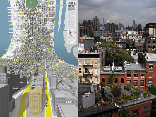
You get used to the Here & There projection really fast. Timo Arnall, friend of S&W, was talking to Jack:
I’ve been sitting here staring at the map, pretty much on and off since yesterday. It comes across as a totally natural projection! … it’s as if you have wired two separate bits of my brain together; the bit that does maps, and the bit that does perspective.
Here’s a comparison:

Thanks Chris Woebken for the photo!
It starts feeling weird that you can’t see over rooftops.
And while these prints we’ve shown so far are tied to two intersections (one looking from 3rd and 7th, and the other from 3rd and 35th), yes we are working on doing it on the fly, and yes we’re looking at generating projections from all kinds of places for one-off prints.
The natural question is, what would this look like driving round Manhattan? (If you forget about the traffic.) As Fast Company and Gizmodo said, Garmin should do it. They totally should. And so here it is.
The Here & There projection is on the left, and the equivalent normal view is on the right. Click through and watch the HD version. It’s cool.
There’s another video too, that shows how the streets distort to make the projection possible.
Here’s what I’d like for my future magic in-car navigation system:
- the superpower to see through the city into the distance
- real-time!
- traffic volume overlaid on the distant city map, with my route
- a way to peek around corners
- seeing further the faster my car is going
Any more?
16 Comments and Trackbacks
1. Eric Rodenbeck said on 8 May 2009...
More? Why, where the cabs are, of course
2. Boris Anthony said on 8 May 2009...
I figured this was available. You don’t model Manhattan in 3D to just make a poster. 😉
Garmin? Um, Google Maps and Earth have all this data. Why not build something that pulls from their API and render it through your process? (sounds easy but prolly hard yeah?)
Gorgeous awesome. You guys are *really* ripping cartography a new one… 😉
3. Eric Rodenbeck said on 9 May 2009...
Also I keep meaning to send you guys this:
http://farm1.static.flickr.com/168/456284854_377faad8ca_o.jpg
from here:
http://mooonriver.blogspot.com/2007_04_01_archive.html
it’s the exact inverse, of course, but still thought it might be of interest
4. Tiffany said on 12 May 2009...
Wow, i can’t wait for this to be the new type of GPS this is great!
5. Rob Stokes said on 15 May 2009...
Excellent idea, but if the device is an in-car GPS, you’d need one that swivels into portrait mode. Normally GPS units rest in landscape mode.
6. Nic said on 12 June 2009...
This is game-space toggling, love it!Like Mr de Certeau on the 110th floor of the tower of Babel: “It’s hard to be down when you’re up”. Well— not anymore.
7. Trevis Thirdgill said on 15 June 2009...
Please make this happen! the translucent overlays on real buildings is just another genious attribute to this whole concept. This coupled with augmented reality contact lens displays would be the ultimate gps technology. A fully immersive AR GPS experience… its like something out of denno coil, only better!
8. Robert White said on 17 June 2009...
(1) I won’t be surprised if we see this on the dashboards of automobiles pretty soon–I’m impressed!
(2) I guess the next problem is how to make a seamless representation of the whole planet. Is it doable?
9. Tristan Ferne said on 29 June 2009...
Watching the video above reminds me that cities seem to have a tendency to remove all sense of elevation and relief from the landscape (from John Reader’s “Cities” I think) and the Here & There rendering looks like it does that even more.
Trackback: GPS Obsessed » Blog Archive » What if PND maps had no horizons like Hear & There? - GPS, Location-Based Apps, And Everything Else Navigational 9 May 2009
[…] Read […]
Trackback: Here & There. Mapping A Horizonless Manhattan | hellokinsella 16 May 2009
[…] Video of how GPS could work in a bendy Manhattan — read […]
Trackback: Pigsaw Blog » Blog Archive » Bookmarks for 19 May 2009 19 May 2009
[…] Pulse Laser: What if GPS worked like Here & There?Some thoughts on the Here & There map of Manhattan — plus a video: "The Here & There projection is on the left, and the equivalent normal view is on the right. Click through and watch the HD version. It’s cool." (mapping visualisation video new_york manhattan ) […]
Trackback: alta4 Geoinformatik AG » totally natural projection: Here and There 2 June 2009
[…] Weiterlesen: http://schulzeandwebb.com/blog/2009/05/08/if-gps-had-here-there/ […]
Trackback: The map is not the territory : The Next in Line 21 July 2009
[…] Image courtesy of Here & There See also: http://schulzeandwebb.com/blog/2009/05/08/if-gps-had-here-there/ […]
Trackback: The map is not the territory « SWC 200.008: Rewriting the World with Google Maps 21 July 2009
[…] Top image courtesy of Here & There See also > […]
Trackback: Here & There: Horizonless Maps of the Big Apple « Metrosetter 15 January 2013
[…] Source: BERG […]